


 9 / 196

T W E N T Y T H I R D E D I T I O N
T H E B U I L D I N G C O N S E R VAT I O N D I R E C T O R Y 2 0 1 6
9
1
PROFESS IONAL SERV I CES
THE ARCHAEOLOGICAL
INVESTIGATION AND
DIGITAL DOCUMENTATION
OF HISTORIC BUILDINGS
TOM ADDYMAN
T
HE PLANNING
process now routinely
imposes archaeological conditions on
work to historic structures, including
recording, investigation, analysis and
monitoring during works. Major custodians
of historic buildings and sites, particularly
the national statutory bodies responsible for
monuments in care, now regard proper survey,
recording and analysis as a necessary aspect of
responsible management and an integral part
of informed conservation.
Archaeologists have long been involved
in the analysis and recording of architecture.
In recent decades, and in the past decade
in particular, the field has developed
dramatically due to a digital survey revolution.
Today, those involved in curating and
repairing historic buildings and sites and
those responsible for the commissioning of
survey work are presented with a broad array
of techniques and options which support the
recording process.
Increasingly it is the archaeologist’s role
to manage the process of digital survey, to
oversee survey specifications and to ensure
that data capture and modelling are properly
planned and implemented. This role requires
archaeologists to precisely identify the desired
outputs, determine resolutions and carefully
consider the final desired result in relation to
the client’s needs.
In the process of commissioning survey
work it is often the buildings archaeologist’s
own requirements within the existing
guidance that are the most stringent. Beyond
obtaining the dimensionally correct data
that is needed to generate the 2D and 3D line
imagery desired by the architectural practice,
the archaeological record will commonly
require exhaustive detail of a site. This takes
the form of high resolution imagery that
allows the complexities, structural nuances,
minor alignments, textures and colours of the
subject structure to be examined in detail and
then retained as a permanent primary archive.
3D DATA AND THE ROLE OF THE
SURVEYOR
For decades the surveyor captured 3D data
but supplied 2D information in the form
of topographic survey drawings, building
plans, elevations and sections. In most
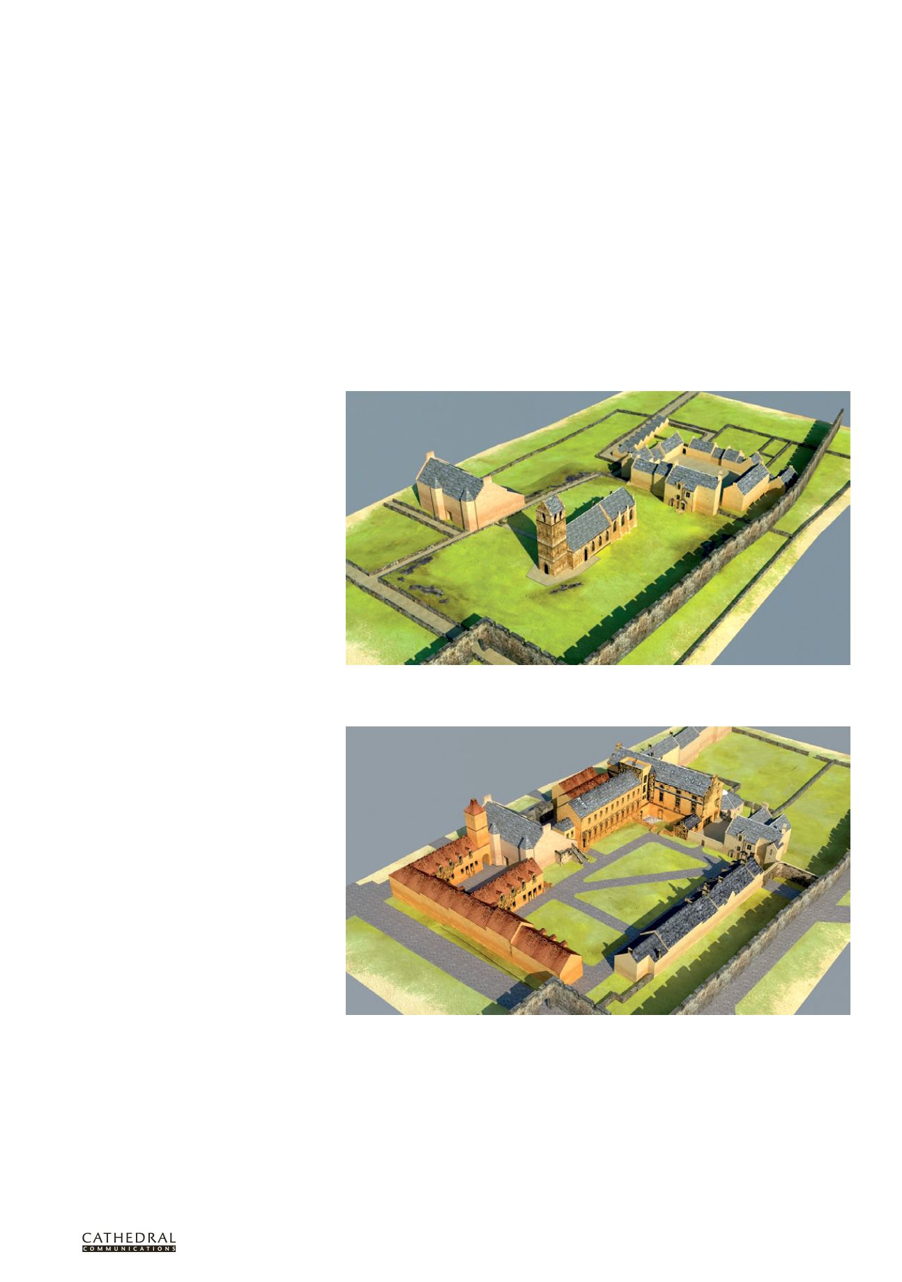
Figure 1 The site of Edinburgh University’s Old College in pre-Reformation times (c1530): the modelling is based
on excavations, early drawings and map evidence (Both images: Luma3D Interactive/Addyman Archaeology/
University of Edinburgh)
Figure 2 The same perspective of the site showing the Old College as it had developed by the later 18th century:
note that in this case the evidence of historic drawn views has been applied directly to the model surface
cases the third dimension was represented
by annotations or contour lines. The
relationship between the surveyor and the
client was, in the main, well understood.
The client defined the end-product and the
surveyor used the appropriate technology
and methodology to satisfy client needs
cost-effectively within the remit.
Now, however, with the increasing
demand for high resolution imagery, virtual
or augmented reality, the development
of 3D city models and, perhaps most
importantly, the mandating of Building
Information Modelling (BIM) by the
UK government, 3D data is becoming an
essential deliverable within the process.