


Measured Building Surveys
Stephen Booth
 |
|
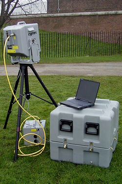
| The machine used by Plowman Craven & Associates is a Cyrax model 2500, developed by US company Cyra Technologies; now part of Leica Geosystems. |
Imagine setting up a small machine on a tripod in the middle of a room. You switch it on. It hums and buzzes for a few minutes as it scans and rotates. At the end of a few minutes activity it has captured enough data to produce accurately dimensioned drawings of all the room’s features – window reveals, mullions, transoms and soffits, intricate cornices, perhaps the balustrade of a minstrel’s gallery or even the complex mouldings of Grecian columns. Welcome to laser scanning.
From the data the laser scanner has captured during its brief period of activity, not only sections and plans can be generated, but also a three-dimensional model for use within a CAD system or perhaps for incorporating in a virtual reality scene or other computer modelling system. The potential is vast and the results are very impressive.
One of these advanced machines is already being used in the UK by Plowman Craven & Associates as an alternative to conventional survey techniques. To date the survey company has applied the scanner to a range of projects, which include one of London’s historic bridges over the River Thames; an art deco department store in the West End; a barrel-vaulted ceiling to a railway terminus; and the complex iron and steelwork of a Tilbury fort in the Thames estuary.
PROFESSIONAL SKILLS NEEDED
As well as the substantial investment in cash and learning time required, the effective use of a laser scanner also needs the skills of a professional surveyor, initially to evaluate its suitability for a particular project, but also to process the data. These machines capture vast amounts of data – a point cloud – very quickly, and it takes a surveyor with knowledge of building construction as well as laser scanning to know what can be discarded and what data is necessary for the final drawing or digital CAD model.
So how can a laser scanner help in building conservation? Building renovation and conservation projects invariably need accurate plans and drawings of the existing layouts and features before the specialists can begin their work. But historic buildings are notoriously poorly documented and accurately dimensioned drawings either don’t exist or have been lost with the passage of time. Even structures built in the 1960s and 70s often lack any detailed record of how they were built and in some cases are beginning to pose a hazard for those who have to alter or demolish them.
Traditionally, surveyors have been called in to produce accurate, as-built, drawings for buildings using the tools they’ve always used: steel tapes, theodolites and, for the intricate and otherwise untouchable or unreachable features, photogrammetry – a painstaking process of measuring accurate dimensions of complex shapes from photographs. Some of this work has become easier in recent years with the arrival of reflectorless distance measurers. These small EDM units, often incorporated within the surveyor’s total station, can accurately measure distances of up to 200 metres without the need for reflective targets. They usually incorporate a visible red dot laser so that the user can see exactly what point is being measured to. The distances captured, when fed into suitable software, can help the surveyor slowly build up an accurate 3D model of both the exterior and interior of a building’s features. But this technique can be time consuming and expensive for clients.
Measurement technology has now evolved a stage further. Instead of a point-and-press EDM collecting measurements one at a time, a laser scanner automatically and rapidly captures a vast swath of points, either horizontally or vertically, to build up a 3D image. The scanning process used by the Cyrax machine is controlled by a laptop computer which also ensures that each scan taken overlaps sufficiently to create a complete and accurate picture of the scene.
 |
|
 |
|
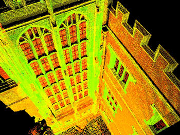
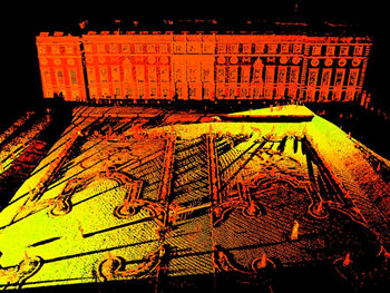
| The scanner is capable of capturing detailed data externally such as this oriel window as well as larger scenes, such as the Privy Gardens at Hampton Court. |
The laser scanner works on similar principles to the EDM but much more rapidly. It also has the advantage of being able to capture all of its data from ground level; no scaffolding, hoist or crane is necessary as the scanner can do its work at ranges of up to 200 metres from the surfaces being measured. The accurate measurement of the scanner’s laser pulse (which is emitted at a rate of up to 1,000 per second) is critical and can be a major source of errors in the hands of an inexperienced operator. Experienced surveyors can then carefully analyse and process the point cloud data so that the most accurate measurements possible are captured for drawings, as well as ensuring that digital files are not overloaded with surplus data. The density of the point cloud captured will depend on the range of the scanner from the surfaces being measured: the closer the range the denser the point cloud.
SOFTWARE AND MODELLING
The quality and accuracy of data collected will depend on processing software, the skill of the operator and the surfaces being measured to. White masonry and other lightly coloured surfaces produce better results/are easier to measure to than darker ones, with black rubber being the most difficult surface to work with. The software is a key component of the system. It is important to appreciate that much of the point cloud data captured will be superfluous and therefore the software’s ability to recognise distinctive features such as lines and curves is essential. If it doesn’t do this, unnecessarily large amounts of data will be processed, slowing the computer system and producing cumbersome files which are slow to load or copy. The processing stage, which is carried out back at the office, is often easier if a video camera has been incorporated with the scanner to provide the operator with an accurate visual record of the features which have been scanned. The video record also provides a useful archive source for building owners.
HISTORY
Laser scanning systems first became available in the US in the mid 1990s and quickly found use amongst oil refinery and chemical plant operators who had seen their plants evolve and change over time but without accurate as-built drawings being kept. Within such plants the cost of shut down while changes or renovations are carried out can be enormous and therefore owners want to limit downtime to the absolute minimum. The use of a laser scanner to create an accurate as-built record of an area perhaps hazardous for humans to access has been of great advantage to operators.
 |
|
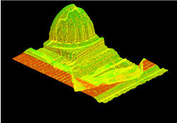
| RAH Complex Mesh: At close range, complex shape |
The application of laser scanning to the survey and recording of buildings has been pioneered by Plowman Craven & Associates in the UK. The company is one of a small number of larger survey companies which have evolved into managers and processors of data by using a range of software and modern system-based technologies such as laser scanners. The term ‘geomatics’ is increasingly applied to these activities and the Royal Institution of Chartered Surveyors, which now operates through 16 faculties where each member can choose to belong to up to four faculties, has a dedicated geomatics faculty.
The arrival of laser scanners for building surveys heralds a new era – not just for surveyors but also for building owners and managers who need accurate plans and drawings quickly, without the inconvenience of providing special access equipment or of fitting targets and other measurement markers which may damage surfaces. Laser scanning also offers the potential to move into 3D modelling with the confidence that the data captured is an accurate representation of every detail of a building or structure, however complex or intricate the detailing. There is little doubt that this exciting new technology will be used increasingly as an alternative to existing methods.
~~~
Recommended Reading
Engineering Surveying Showcase:
- 'Laser
Scanner provides As-Built 3D data for Refinery Upgrade',
October 2000
- 'Scanner opens new doors', April 2001
Geomatics World (formerly Surveying World ):
- 'Redefining the three R’s - Reflectance, Resolution and Reference: Important considerations for Laser Mapping Systems', May/June 2001
- 'Close-range laser scanning case studies', November/December
2001
Note
EDM: electromagnetic distance measurement. A term widely used by surveyors and engineers to describe a range of devices from handheld measurers such as the Leica Disto, now widely used in construction, to very precise long-range measurers for control surveys. Many EDMs today will be found incorporated with a theodolite and data recorder within a total station.