


Rectified Photography
James Brennan
 |
|
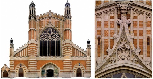
| Rectified image of the west front of Holy Trinity, Sloane Square, London: the detail to the right was taken from the same image to illustrate the amount of detail visible. The facetted towers were also photographed and rectified separately. |
Rectified photography provides a cost effective method for recording a high level of detail on relatively flat structures and objects such as building facades, floors, stained glass windows and wall paintings. It can be used to produce a highly versatile ‘drawing’ which can be taken on site and easily annotated, read and understood by the many different specialists involved in building conservation. By its very nature it provides a detailed photographic record of the subject at a point in time. The resulting images are also often impressive and can be used for publicity and fund-raising. It must, however, be remembered that the technique is only really effective for relatively flat structures and objects. If a similar image is needed of, for example a vault or 3D line work, more complex techniques such as orthophotography and traditional photogrammetric stereo plotting can be used.
Producing rectified images can be a relatively simple process using a compact digital camera and a tape measure or a more specialist process using high quality distortion-free cameras, measured control points and dedicated software. It can also be combined with other measured survey information such as line work. Whichever method is chosen, rectified photographs can communicate a great deal more information than most traditional line work drawings; a picture speaks a thousand words.
WHAT IS RECTIFIED PHOTOGRAPHY?
In its most basic form it is a photograph ‘with the image plane of the camera approximately parallel to the principal plane of the object and then printed to scale’ (Bryan et al 2007). In other words the effects of distortion by perspective are removed and the image scaled upon one or more principal planes of the subject. Measurements taken off the rectified image are only accurate on these scaled planes. A good example would be the front elevation of a typical Georgian terrace town house. Once the perspective is removed, the image is scaled on the flat brickwork of the facade. Measurements between window cuts would be accurate. Measurements taken on the projecting cornices would be too big, those on a recessed fan light too small. These single images can be formed into mosaic composites.
HOW IS IT PRODUCED?
Until recently rectified images were produced in the darkroom. The advent of higher quality and more affordable digital cameras has made the techniques easier and more flexible.
When rectified photography is commissioned, first decide what scale the final output will be. The greater the scale, the more detail will be visible but more images will be required. More photos equals higher costs, which may be unnecessary for the work in hand.
To some degree, every photograph contains distortions: most obviously perspective and barrel distortion. Some of these can be removed by the use of high quality ‘shifted’ lenses. Each picture should be taken square on to the subject and if possible the effects of perspective removed by shifting the lens accordingly. Good even lighting conditions are desirable to reduce shadows to a minimum or eliminate them altogether as they represent a loss of information, and can result in extra work for either the surveyor at the time or possibly an end-user. However, ideal conditions are unattainable, and the images may be slightly oblique and/or tilted. This results in more images being taken on site and will certainly result in more work in the office.
 |
|
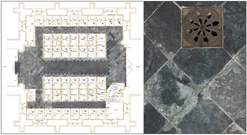
| Measured survey drawing and integrated rectified image of the stone floor of the nave of Staunton Harold Church: the detail to the right is taken from the same image, illustrating the amount of detail recorded. |
The choice of camera will depend on the quality and end-use of the image required. More expensive tripod-mounted professional cameras, the dedicated software that accompanies them and high quality lenses will produce impressive images with amazing resolution. The example of a church floor mosaic, above, illustrates the point: the user can see the whole area or zoom in to assess the condition of one individual stone slab. However, perfectly usable images of simple subjects can also be produced with a compact digital camera. The resolution will not be as good and there will be more distortion, but if the end result is suitable for its use then there is no need for a more expensive solution.
The measurements or ‘control’ needed to scale and fit single images together into a mosaic can be collected in different ways. Taped dimensions may be fine across grave slabs, but for the elevation of a cathedral, electronic distance measurement (using reflectorless EDM) may be the only practical solution. Four points are required for removing distortion and to scale the image. Photographs can be rectified in different software packages including Photoshop or more dedicated programs like Phidias or Photoplan. The final images are often imported into CAD software, and borders, text and annotations may be added before printing.
HOW IS IT USED?
The cost of producing rectified elevations is relatively low compared to other aspects of conservation work and can save a great deal of time for other specialists. The images give a good overall picture of the subject before being obscured by scaffolding, and a surveyor, architect or archeologist can annotate the elevation once scaffolding is erected.
 |
|
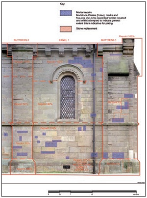
| Rectified image of Holy Trinity, Anslow, Staffordshire, including specification annotations added for the conservation and repair by Alan Gardner Associates |
Areas of surface requiring repair or conservation can easily be measured and calculated from the images. These should be accurate enough for a schedule, pricing and on site repair. For example, rubble-built walls can be costly to have drawn stone by stone, but individual stones will be clearly visible in a rectified photograph and areas requiring repointing, consolidation or replacement can be marked up on the image and measured. Buildings archaeology phasing information can also be added either to the same image or to another copy.
The images provide a less subjective record than a drawing, as the use of line and shade to indicate features relies on interpretation and experience. A rectified image of an elevation, floor or wall painting will show not just the outline of a stone block or area of lime plaster but clearly the damage to the block or fragment of wall painting on the plaster. The process is non-contact and is ideal for fragile surfaces or structures.
The same images can also be enhanced for visualization purposes. What, for example, would that streetscape of early Victorian terrace houses look like if all the mismatching or uPVC front doors and windows were replaced through a grant from a townscape heritage initiative? Similar imagery can be used for interactive computer-based site interpretation or reconstructions.
This cost-effective survey method can be used to great effect on different subjects, providing a great deal of information for many different specialists and the general public. While it has limitations, it has been proven by many people to be another valuable way of recording and surveying in the conservation of historic buildings. As with any other method, including laser scanning or stereo photography, it should only be used where appropriate, and it should be avoided if another easier technique can be used to similar effect. It does, however, produce a massive amount of clearly understandable, easily readable information.
~~~
Recommended Reading
- DP Andrews et al, ‘Photographic Survey of Mosaic and Tiled Floors – a Methodology’, New Perspectives to Save Cultural Heritage, CIPA 19th International Symposium, 2003
- D Ayala et al, Minimum requirement for metric use of non-metric photographic documentation, University of Bath (report), 2003
- JEO Brennan, ‘The use of rectified photography at the Painted Hall’, Conservation News, issue 87, 2003
- P Bryan et al ‘Digital rectification techniques for architectural and archaeological presentation’, Photogrammetric Record, 16 (93), 1999
- CM Clark, Informed Conservation: Understanding Historic Buildings and their Landscapes for Conservation, English Heritage, London, 2001
Acknowledgements
The National Trust, Rodney Melville, Richard Stiles, Alan Gardner, Alan Gardner Associates, Dan Martin, Biscoe Craig Hall and the Church of the Holy Trinity, Sloane Square, London.