


Photogrammetry: A Practical Guide
Rory Stanbridge
 |
|
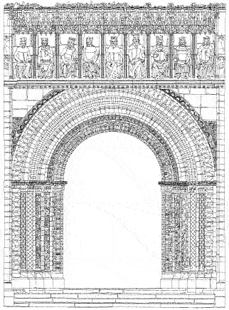
| Part of a photogrammetric survey of the West facade of Lincoln Cathedral |
Photogrammetry is the practice of obtaining information about physical objects through the process of recording, measuring, and interpreting photographic images. It is most commonly associated with the production of topographic maps through aerial survey, although in recent years it has been increasingly used in such diverse applications as architecture, archaeology, engineering, geology, underwater, and forensic work amongst others. In fact it may be used in any situation that requires the generation of accurate three-dimensional data or precise drawings, and is ideally suited to the survey and measurement of buildings and monuments. This article focuses on the application in relation to the survey of buildings.
Although the major part of a photogrammetry project is carried out in an office, the procedure commences on site by taking suitable photographs, usually stereoscopic, and establishing a 'control' network to determine the scale and orientation of the photographs and enable accurate photogrammetric analysis. The site time represents only a small part of a project and is generally completed in a day or two even on large buildings or those of a complex nature.
An architectural project may comprise any number of stereo models. The photographs are taken using precision cameras, commonly known as metric cameras, and full stereoscopic coverage of the building to be surveyed is produced. Control information may take the form of either taped distances on the facade of the building or the establishment of three dimensional coordinates of either target markers or identifiable points of detail. A minimum of two scaled distances or three coordinated points is required per stereo model. The choice of method depends on the scale and accuracy requirements of the final data. English Heritage has now produced a specification for the production of photogrammetric surveys which provides guidance on all of the above. I would strongly suggest that any person contemplating the requisition of a photogrammetric survey obtains a copy of this specification, or at least refers to it in the request for a price.
The axis around which the survey revolves is the production of the photogrammetric data. To undertake photogrammetric analysis, a photogrammetrist will place a pair of stereo photographs in an instrument and undertake certain procedures which will allow a true stereo model to be viewed. The best way to visualise this is perhaps to relate to the Viewmaster type of stereo viewer where the user sees a 3D or stereo image. In the case of a photogrammetric instrument, the operator can, with the application of a reference mark in the optics of the instrument, digitise points of detail on the object being measured, either as continuous lines or individual points. All points so digitised are recorded as a three dimensional point or string. The data is then correlated with the ground control, and scaled drawings or CAD data is then provided.
The accuracy achievable on a photogrammetric survey is linked directly to the accessibility of the object being photographed and the scale of the photographs produced. In building surveys an accuracy of 10mm is generally achievable on a 1:50 survey, although even this can be improved upon. In most instances the final drawing or data will be accurate to better than a line width on a drawing of a comparable scale.
The usual end-product of a photogrammetric survey is the production of either digital data or a line drawing. The data may be formatted for use in most commonly used CAD systems, thereby offering the advantage of total flexibility. As the process requires photography, this may become the end-product itself, either archived as they are, or as a rectified mosaic composed of a number of scaled photographs joined together. The last few years have seen a dramatic decrease in the cost of CAD systems, making the use of photogrammetric data both more efficient and cost effective.
An alternative end product to data is a rectified or an ortho photograph. In both of these cases, the site photography is corrected for angular distortion, re-scaled and output as a digital file or film copy. Rectified photography is suitable for elevations containing a single plane, ortho photography which is corrected in all planes is more suited to elevations with a number of different planes. The end result is an image from which measurements can be extracted just like a map.
As photogrammetry has become more widely used in the field of architecture, other survey techniques have also become available. Laser scanning now offers an alternative to photogrammetry for some traditional work, but the use of the technique in conservation and restoration work is still in its infancy. Additionally, the generation of thousands of points of detail in the 'point cloud' can be overpowering for the first time user. In my opinion, photogrammetry still provides a better solution for the recording of historic monuments and buildings.
As an alternative to commissioning a photogrammetric product from a professional survey company, cheap 'off the shelf' photogrammetry software packages such as PhotoModeler have now been developed. This is aimed at the non-photogrammetrist and enables the user to undertake simple rectification and measurement tasks. This product, costing about £550, uses the principle of 'multi image' as opposed to stereo photography, and is suitable for many applications. A good consumer camera may be used, with the imagery being taken from a number of positions. The resultant images are then processed and measured on a standard PC. However, it should be emphasized that this approach should only be adopted where minimal levels of detail are required.
THE BENIFITS OF PHOTOGRAMMETRY
-
The photographs may be archived for future use.
-
The photographs may be used either for monitoring or for the generation of data.
-
The technique is non-intrusive.
-
The technique is ideal for recording detail of a complex nature
(see illustration above). -
A high level of accuracy is achievable.
-
The use of digital data ensures total flexibility.
-
The level of detail to be extracted may be determined either by the client or the photogrammetrist.
-
It is cost-effective.