


Historic Urban Buildings and Their Settings
Nicola Adams
 |
|
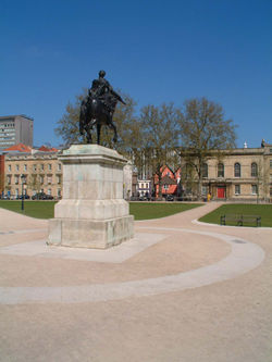
| Queen Square, Bristol, until recently a busy main road |
It has long been recognised that rural gardens, landscapes and estates form an intrinsic part of the significance and architectural value of the historic buildings they surround. While the settings of smaller vernacular buildings may still be threatened by development and agricultural onslaughts, there are few country houses or rural churches whose surrounding landscape is not as valued and appreciated as the buildings themselves. In contrast, in urban settings, land prices and economics almost invariably lead development ambitions, and even buildings of national significance can find their surroundings compromised. Areas that are not recognised as urban parks or gardens or examples of historic urban planning are often neglected to the detriment of the historic buildings they surround. The statutory defence afforded by conservation area protection often only enforces the rule rather than the spirit of the law. Whilst the buildings themselves are protected, their surrounding spaces, where not officially regarded as ‘curtilage’, often remain under threat.
The importance of setting and urban space around historic buildings is not just a question of aesthetics. The rich archaeological potential of urban sites is nowhere more valuable than around those built manifestations of historic urban life which have survived into modern use. The rigorously defended network of legal boundaries that have historically defined our cities has promoted the perception of single, isolated plots, autonomous amongst a city of others, to proliferate and endure, at the expense of our perception of the whole. In urban developments, even those based on the conservation of an historic building, there is often little recognition for the importance of the built remains as the visible upstanding component of the wider archaeological fabric of the city. Development adjacent to historic buildings can, at worst, destroy surrounding archaeological remains for centuries, or at least deny access to them, and the obligatory rescue archaeology or watching brief can only partially ameliorate the effects.
The battle for recognition of the importance of the setting of urban historic buildings is being fought every day in planning, project development and financial meetings in towns and cities across the country by those who recognise that the special qualities of the historic buildings which we value do not begin and end at the doorstep. Unfortunately, many of these battles are lost and our architectural and archaeological heritage is the poorer for it. However, some battles are won and the buildings in question are given space within which to breathe and an environment where their qualities can be appreciated.
 |
|
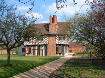
| Blakesley Hall, Birmingham, after repairs | |
 |
|
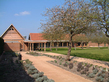
| Blakesley Hall, new visitor facilities |
The following three case studies illustrate a selection of conservation projects where the importance of the open spaces around and between historic buildings has not only been considered but has been identified as a driving factor in the development of the scheme. At differing stages of completion, they are offered as examples where, for a combination of reasons such as enlightened clients and funding bodies and sympathetic and supportive local authorities, existing spaces, although previously neglected, were reviewed and recognised as historic assets in their own right.
BLAKESLEY HALL
The first example is a late Tudor yeoman’s house of c1590 and its grounds at Blakesley, Yardley, near Birmingham. Blakesley Hall was previously set in its own farmland but only six miles from the centre of Birmingham, it is now tightly surrounded by suburban development. The house has been used as a museum since 1935 and its interior has been reinstated to its mid 17th century appearance as derived from inventories of 1648. However, its visitor potential was restricted by a lack of parking and visitor facilities, as well as by a lack of secondary exhibition space. The boundaries to the limited formal gardens that remained were poorly defined and security was difficult to control. The garden did not clearly respond to the hall and the adjacent, uninspiring housing scheme compromised views of the building. To the north, Blakesley’s formal gardens are bounded by playing fields that are held in trust for public amenity, but little used. The existence of this open space had both detrimental and beneficial effects on the hall. The playing fields provided a green setting for the hall but the lack of organised use encouraged vandalism. The gardens provided an attractive setting for the hall and were used for educational events. However, the perception of the grounds as not wholly self-contained and the poor definition between the garden and the playing fields beyond, prevented the full potential of the site being reached.
A project was proposed to provide a further gallery, visitor facilities and improved education space on the site, with increased parking to accommodate the predicted rise in visitor numbers. The brief required the new development to improve the perception of the space surrounding the hall and to tackle the problems of security and vandalism that had been identified. At the same time a programme of repairs were scheduled for the hall itself.
After the consideration of many strategic planning options with the client, a scheme was developed which included a new building carefully designed to complement the hall and affirm the boundaries of the garden. This new building is L-shaped in plan and defines the corner of the rectangular site that is diagonally opposite the hall so providing the enclosure that the gardens needed. Entrance to the site was relocated to the heart of the new building giving a sense of arrival and a definite edge between land belonging to the hall and that of the surrounding suburb. Existing parking within the hall grounds was relocated and expanded by converting an unused bowling green on the boundary with the playing fields to a landscaped car parking area. This enabled a buffer zone to be created between the playing fields and the hall grounds. The formal gardens were redefined with gravel paths and planting more in keeping with a 16th century hall. The landscape scheme includes a large herb garden and fenced boundaries that have been planted with native hedge species.
QUEEN SQUARE, BRISTOL
Queen Square, which dates from c1699, was the first residential square to be laid out outside London, and is lined with a number of 18th century listed buildings including the Custom House of c1710. Despite its importance, the square was radically changed in the 1936 when a major arterial road was redirected diagonally across it. The quality of the space and the graceful setting of the listed buildings were severely affected by the intrusion of high levels of traffic and the condition of the square declined; many buildings of considerable architectural quality stood unlet and unmaintained. The poor regard within which this urban space was held had a direct negative effect on the fate of the adjacent historic buildings which were neglected through lack of occupation and commercial interest.
In 1992 a scheme generated by the local planning department and backed by English Heritage was instigated which implemented the removal of both the arterial road across the square and the accompanying bus routes. The square was restored to its former layout of diagonal walks of c1776. The scheme, now in its final phase involving details such as the reinstatement of former boundary walls, railings and gates to original designs, has improved the quality of this important civic space and restored its former gentility. An air of prosperity, which was inherent to the square at the time of its construction for a group of rich Bristol merchants, has now returned. Occupation of the surrounding buildings is now almost complete and the benefits to the conservation and maintenance of the buildings can begin to be observed.
ROWLEY'S HOUSE, SHREWSBURY
 |
|
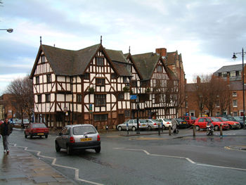
| Rowley's House, Shrewsbury, isolated from Shrewsbury's medieval core |
Conservation plans are the most common means by which the significance of the urban spaces around historic buildings is now identified. If the context of an historic building is not to be neglected, it is essential that its importance is fully identified, and conservation plans aim to achieve this.
This principle has been recognised in the Conservation Plan and Feasibility Study for Shrewsbury Museum and Art Gallery, known locally as Rowley’s House. The building is a combination of an early 17th century mansion and a warehouse and has been the site of Shrewsbury’s main museum since the 1930s. The museum is in the centre of what was the medieval merchant quarter of the town. Both structures were originally restricted in their design by the densely occupied streetscape in which they were constructed. However, both warehouse and mansion are magnificent examples of 17th century design and craftsmanship. After a programme of inter-war slum clearance the building now stands isolated surrounded by a desert of tarmac-covered car-parking space.
When the adjacent buildings were demolished, the remaining space was left undeveloped and was used as a bus terminus before its present incarnation as a car park. The area around the museum is now rundown and in need of regeneration. The building itself is unable to accommodate the varied demands made on modern museums. Desktop archaeological assessments have identified the open space around the museum as of considerable interest, an asset which to date has been ignored.
A conservation plan has been prepared which reinforces the need for the building to be considered within the context of its site and re-evaluates the relationship between standing and buried archaeology. At present, the museum is strangely dislocated from its surroundings and stands aloof from the remaining medieval street pattern that re-asserts itself beyond the car park boundary. A feasibility study has also been prepared which identifies ways in which the site could be redeveloped to enhance the museum’s facilities whilst weaving Rowley’s House back into Shrewsbury’s urban grain. The proposed scheme respects the need for public open space whilst giving structure and definition to the area, replacing the soulless wasteland that presently exists. It is hoped that such consideration of Rowley’s House as one artefact amongst a town full of others, both tangible and hidden, will result in development which restores both a much needed sense of place and a historic dialogue between structure and space.
If urban space is to respond to the historic and contemporary buildings that define it, as illustrated at Blakesley and Queen Square and recommended at Rowley’s House, our perceptions of buildings as autonomous units must be broken down. Just as historians have moved on from event-based study and archaeologists from concentration upon monuments and features, those responsible for the built environment must broaden their understanding and input beyond the boundaries of their sites and consider the spaces between buildings and the city beyond. The complex web of continuous human occupation that our cities represent, is defined equally by both the solids and the voids of which they are made. Valliant protection of the former should not neglect the latter if urban complexity and vitality is to be maintained.