Basic HTML Version


4 2
t h e b u i l d i n g c o n s e r v a t i o n d i r e c t o r y 2 0 1 2
1
Laser Scanning
Surveying, recording and monitoring historic buildings
James Miller
T
he use
of laser scanning techniques
for surveying is now commonplace. Ten
years ago a measured survey would have
been carried out using a computerised EDM
(electronic distance measurement) device such
as a total station and ‘smart pole’, together with
hand-held tools, but today’s surveyor is likely
to be equipped with a tripod-mounted scanner.
Heritage professionals are likely to be
more interested in having an accurate drawing
on which to base their specification of works
than in the process behind it. However, laser
scanning is radically different from previous
techniques, and it is well worth taking a
moment to grasp the concepts, not only to take
advantage of the new opportunities it offers,
but also to avoid paying for unnecessary detail.
Laser scanning techniques
The technique requires a scanning head to be
mounted on a surveyor’s tripod. The scanner
spins at very high speed while a low-energy
laser fires a reflecting beam with extraordinary
precision, recording up to 1 million points
a second. The density of these is adjusted
according to the purpose of the survey, with
a typical spacing of 1–3mm. There might, for
example, be 20 million points in a survey of
the front facade of a modest Grade II listed
cottage. The tolerance of the position of each
point is typically 1–2mm. Together they
effectively describe the surface and are known
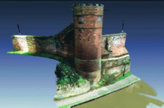
as the point cloud. Figure 1 shows a colour-
mapped image of the point cloud for King
Charles Tower on Chester’s city walls.
Safety is a common concern for
neighbours and bystanders. Lasers used for
such work are of Class 3R or lower intensity
in accordance with IEC standard 60625-1 and
under normal use the beam is not harmful
to the human eye. Legislation may require
warning notices to be displayed while site work
is carried out and the surveyor should have
a method of work that mitigates exposure.
Survey set-up
Obviously, the device does not have X-ray
vision. To give a complete picture it must have
sight of the features to be surveyed (as with the
more traditional total station), so a number
of different set-up positions will need to be
adopted inside and outside the building. It may
need to include roof voids and positions on or
overlooking the roof itself if an accurate roof
plan is required. Laser survey equipment has
become lighter and can now be mounted on
an extendable pole, although sway may result
in error. Even so, it is often impossible to avoid
areas of shadow on the point cloud where
surfaces are hidden behind other fabric, and
data is lost. In such cases some assumptions
must be made later to fill in the gaps.
The set-up position does not need to be
located over a survey ‘station’ (a nail head
or pin), which is traditionally used to tie the
survey together. Instead, the survey company
will commonly use their own objects, typically
spheres, to correlate the dataset from one
location with that taken from another, as
shown in Figure 2. Each piece of survey is then
fitted together like a jigsaw so that the edges
match to form a whole.
The scanning of motorways and railways
is now undertaken from moving platforms,
vehicles and even aircraft but, due to the
lower tolerance on such data, this method is
unsuitable for historic fabric.
Current surveying practice
Survey companies have moved rapidly to
embrace laser techniques because they reduce
both the costs and the risks associated with
site work. The time needed to record data can
be as little as ten minutes per location. By
reducing site activities and transferring them
to the office, the influence of unpredictable
factors such as bad weather are mitigated.
The benefits are significant when
considering large building volumes and
spaces where detail at height is important,
such as cathedrals, tall facades and historic
civil engineering structures. There is usually
no need to gain access at height in order to
register their dimensions. The precise shape
of a historic vault, a bulge in a wall or the
irregular spacing of timbers across a ceiling
can be measured from ground level.
Laser scanning therefore provides a new
approach for the historic building specialist
and a new way of visualising and exploring
historic fabric. Its principal advantages over
previous methods include:
• Recording detail from a distance
The shape and condition of decorative
stonework, corbels, lintels and other
features can be reproduced by the surveyor
at large scale (1:5 or even 1:2 if necessary)
with a tolerance equal to or better than that
obtained by close physical measurement.
• Inspection in low light
The process
is not dependent on the human eye
so can be carried out at night when a
building or site is unoccupied, or with
very low levels of internal light.
• Access to a complete computerised
record
Conservation professionals have
access to all the gathered data in scalable
form on their own computer. They can
jump from one survey position to another
in a 3D environment, interrogating floor
levels, lintel heights and other dimensions.
Figure 1 Colour-mapped image of a point cloud of King Charles Tower on Chester City walls. (Image: Russell Geomatics/
Donald Insall)