


Remote Aerial Survey
Enter the Drone
Robert Demaus
 |
|
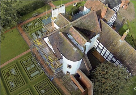
| A drone’s eye view of the roof of Boscobel House, Shropshire |
Until recently, the detailed visual inspection of tall or potentially dangerous structures and inaccessible roofs was a difficult and usually expensive operation, often requiring specialised access platforms or scaffolding, or the use of specially trained rope-access technicians. Even relatively simple tasks such as checking parapet gutters for blockages, that might traditionally have been done from a ladder, have more recently required relatively expensive access provision to minimise risk.
Now an exciting new technology is emerging that allows highly detailed surveys of buildings or parts of buildings that were previously difficult to access, without the operator or surveyor leaving the ground. Unmanned aerial systems (UASs) [1], or drones as they are more popularly known, seem to have flown into the public consciousness only relatively recently, but now hardly a day goes by without some mainstream news item involving their use, or indeed, abuse, with numerous and sometimes wild claims being made about how they might impinge on our lives in the future.
Of course, the terms UAS and drone cover a very wide assortment of devices and an ever-expanding range of real, imagined or potential applications. For most people, the terms remain associated with their military applications and at this level they represent a sinister and questionable form of lethal weapon, or at best, an effective way of keeping a watchful eye on both friend and foe.
However, the type of UAS that is starting to have practical applications in the field of building surveys actually has far more in common with the model aeroplanes and radio-controlled helicopters that enthusiasts have been flying for many years. What has allowed them to develop into a very useful tool is the adoption and integration of the rapidly developing technologies of the mobile phone industry: many of the most important components, such as gyroscopes, GPS units, accelerometers, batteries, and wi-fi transmitters, have all become much smaller, much more sophisticated and very much cheaper due to the intense pressure for innovation. As well as incorporating much of the technology, many systems are now designed to use a smart phone or tablet as part of the control and viewing systems.
Technological advances are so rapid that what might have required a UAS costing several thousands of pounds, can now be achieved using machines that cost only a few hundred pounds. As a result, UAS aircraft now provide a practicable stable platform, ideally suited for controlled visual survey of all types of buildings and other structures.
SPECIFICATIONS
Most types of UAS used for building survey consist of four basic elements:
- The aircraft is usually a battery-powered multi-rotor ‘helicopter’. Typically it will be fitted with an array of technology to allow it to perform as a safe and stable platform. This will include an integrated GPS auto-pilot system which provides altitude lock and position holding, and a stable hovering capability, which allows steady and predictable flight paths even in windy conditions. Flight time depends on many factors including battery capacity, payload and weather conditions, but will be typically 10-30 minutes. This may not seem long, but a lot of building can be surveyed in detail in that time, and if necessary it is simple to land and ‘refuel’ with a fresh battery. Many of the more sophisticated types of UAS will automatically fly back to the point of launch.
- The camera, which can vary from the very small and ubiquitous GoPro to high resolution DSLRs or video cameras. The cameras used are often also fitted with wi-fi, transmitting live video to a screen (often a smart phone or tablet) attached to the remote control unit. Known as ‘first person view’ or FPV, the technology gives the pilot on the ground the view from the plane.
- The base station or remote control unit is essentially the equivalent of the cockpit in a conventional aircraft, with controls for the aircraft’s speed height, direction and orientation. Flight data such as altitude, distance and speed is fed back to the base station along with important safety parameters such as battery condition. It is also often possible to take full control of the camera settings and operation whilst in flight.
- The pilot (on the ground) is kept very busy during the flight. There is a mass of information constantly streamed from the aircraft and the camera to the base station, and the pilot must maintain direct line-of-vision contact with the aircraft at all times. UAS has become very much easier to operate, and with GPS fitted, many aircraft will hover in a geo-stationary position if the operator loses the plot and lets go of the controls: this is not necessarily recommended, but can allow a breathing space to make adjustments to cameras and regain orientation and bearings. Quite apart from regulatory compliance (see below), a pilot needs considerable experience and competence to avoid damage to the aircraft, which are built to minimise weight and are therefore not particularly robust. Furthermore, although lightweight – typically 1-3kg – they could do a great deal of damage to a stained glass window. What might seem to be easy to control and relatively slow moving when flying in open air, suddenly seems very much faster and friskier when close to solid objects.
REGULATIONS
 |
|
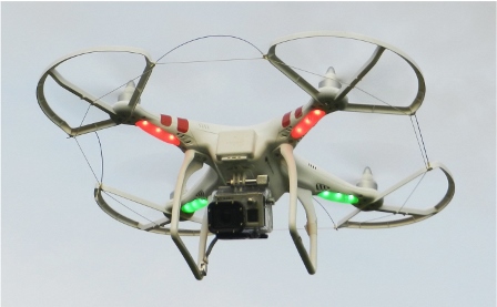
| A typical compact (approximately 500mm wide) four-rotor UAS carrying a GoPro video camera, as used for the aerial survey of Boscobel House. |
In the United Kingdom, the Civil Aviation Authority is the regulatory authority for all matters associated with non-military aviation, including the operation of UAS. Practice and regulation of small unmanned aircraft has evolved out of the hobbyists’ use of radio-controlled model aircraft, and remains reasonably simple and straightforward, but as commercial use of UAS increases, regulations and restrictions are likely to become more stringent.
Essentially, the operator is fully responsible for the safe operation of any flight. In many circumstances a permission (not a licence) from the CAA is required, for example, if you intend to fly the UAS on a commercial basis, or fly a camera/surveillance fitted aircraft within congested areas, or close to people or properties (vehicles, vessels or structures) that are not under your control.
The CAA permission must be renewed every 12 months and requires payment of a modest fee depending on the weight of the UAS. However, the ‘pilot’ does not need any formal qualification (the Basic National UAS Certificate for example) if the UAS is under 20kg and is flown in direct line of sight, within 500 metres horizontally and at a height not exceeding 400 feet. CAA permission is not required for ‘practice’ or demonstration flights, or if the aircraft will not be flown close to people or properties, and there is no ‘valuable consideration’ (i.e. payment) for the flight.
Whatever the circumstance, anyone contemplating any form of UAS flying should familiarise themselves with the CAA requirements (which are clearly defined on their website), demonstrate adequate competence as required and ensure that they have adequate public and professional liability insurance in place, and that they and their insurers do actually understand the competencies required and risks involved.
APPLICATIONS
At present, for the price of a good pair of binoculars, a very capable ready-to-fly UAS can reliably carry out detailed visual surveys of inaccessible areas of buildings and other structures. In a matter of minutes, detailed images of high level stonework, inaccessible metalwork such as weather vanes, chimney stacks and concealed roofs and valley gutters can be obtained. As always, it is far better if the operator of the technology also has great experience of surveying historic buildings, so knows what to look for and where, and is capable of identifying and analysing current and potential faults. With instant FPV images beamed back to the ground, this allows the pilot/surveyor to concentrate in particular detail on specific problem areas.
UAS aircraft can also be flown inside large buildings, but this requires much greater skill than flying outdoors. Proximity sensors are now being developed that will greatly reduce the risk of collision or damage. Payload is always limited, but the aircraft can carry very bright LED lights in addition to cameras, which allows the detailed visual survey of high vaulted roofs in large churches and cathedrals, for example.
Aerial digital images from a UAS can be integrated with terrestrial images of widely different resolutions using currently available software which can then process them to produce 3D models of complex buildings such as castles and cathedrals. Currently accuracy is limited (typically 5mm to 20cm, across a large and complex building, depending on the system used) but should improve over time.
With any new technology, there is often a rush of enthusiasm for its adoption. It is quite possible for anyone to go out and buy a £500 UAS and claim to be able to survey your building. However, it is most important that the operator is just as fully experienced in interpreting and diagnosing faults in historic buildings, as they need to be in operating a UAS.
PREDICTIONS
As in the early stages of any new technology, be it computers, mobile phones or indeed manned aircraft, capabilities massively and rapidly improve and real costs drop. Predictions made in these early stages can appear very wide of the mark only a short time later, but UAS will almost certainly become an accepted and common tool in a specialist surveyor’s toolbox.
 |
|
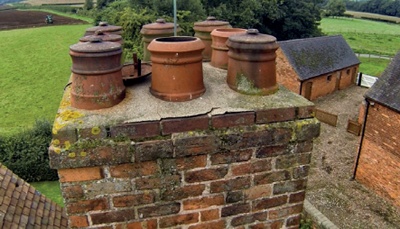
| One of the chimneys at Boscobel: photos taken by UAS can quickly provide important information for a quinquennial inspection and for programming maintenance |
Already, a simple and palm-sized UAS aircraft, but still with on-board camera, video recording and a 100m range, can be bought for under £100 (thumb-sized and smaller are also available). At the moment, a UAS can only inspect and record, and further miniaturisation may not offer much advantage, but greater control and payload capacity might, for example, allow accurate application of weed-killers to inaccessible places.
What makes UAS technology particularly interesting and difficult to predict is that its emergence coincides with the arrival of practical and relatively cheap 3D printers. These two emergent technologies neatly fit in with and greatly strengthen the worldwide growth of the ‘Maker Movement’, with many thousands of individuals around the world openly sharing knowledge and skills. The further development of UAS for civilian and specific uses does not depend on military funding or even big business.
At the current state of development, compact and modestly priced UAS can reliably provide detailed information that would otherwise require the use of expensive and time-consuming scaffolding, hydraulic access platforms or specialist rope-access. A tall, dangerous or inaccessible structure can be surveyed very economically in a few minutes, that might otherwise have taken many days and cost thousands of pounds. It therefore becomes economically viable to check potential trouble spots such as inaccessible valley and parapet gutters on a regular basis. At the very least, a UAS survey should be considered an essential element of every quinquennial survey.
Notes
[1] The Civil Aviation Authority prefers the term Unmanned Aerial Systems (UAS), as this is deemed to include the operator on the ground as part of the system, but Unmanned Aerial Vehicle (UAV) and drone remain in popular use.