


 44 / 208

4 2
T H E B U I L D I N G C O N S E R VAT I O N D I R E C T O R Y 2 0 1 5
T W E N T Y S E C O N D E D I T I O N
1
PROFESS IONAL SERV I CES
REMOTE AERIAL SURVEY–
ENTER THE DRONE
ROBERT DEMAUS
U
NTIL RECENTLY,
the detailed visual
inspection of tall or potentially
dangerous structures and inaccessible
roofs was a difficult and usually expensive
operation, often requiring specialised
access platforms or scaffolding, or the use
of specially trained rope-access technicians.
Even relatively simple tasks such as checking
parapet gutters for blockages, that might
traditionally have been done from a ladder,
have more recently required relatively
expensive access provision to minimise risk.
Now an exciting new technology is
emerging that allows highly detailed surveys
of buildings or parts of buildings that were
previously difficult to access, without the
operator or surveyor leaving the ground.
Unmanned aerial systems (UASs�), or drones
as they are more popularly known, seem to
have flown into the public consciousness
only relatively recently, but now hardly a day
goes by without some mainstream news item
involving their use, or indeed, abuse, with
numerous and sometimes wild claims being
made about how they might impinge on our
lives in the future.
Of course, the terms UAS and drone
cover a very wide assortment of devices and
an ever-expanding range of real, imagined or
potential applications. For most people, the
terms remain associated with their military
applications and at this level they represent
a sinister and questionable form of lethal
weapon, or at best, an effective way of keeping
a watchful eye on both friend and foe.
However, the type of UAS that is starting
to have practical applications in the field
of building surveys actually has far more
in common with the model aeroplanes and
radio-controlled helicopters that enthusiasts
have been flying for many years. What has
allowed them to develop into a very useful
tool is the adoption and integration of the
rapidly developing technologies of the
mobile phone industry: many of the most
important components, such as gyroscopes,
GPS units, accelerometers, batteries, and
wi-fi transmitters, have all become much
smaller, much more sophisticated and very
much cheaper due to the intense pressure for
innovation. As well as incorporating much
of the technology, many systems are now
designed to use a smart phone or tablet as part
of the control and viewing systems.
Technological advances are so rapid that
what might have required a UAS costing
several thousands of pounds, can now be
achieved using machines that cost only a few
hundred pounds. As a result, UAS aircraft
now provide a practicable stable platform,
ideally suited for controlled visual survey of all
types of buildings and other structures.
SPECIFICATIONS
Most types of UAS used for building survey
consist of four basic elements:
• The aircraft is usually a battery-powered
multi-rotor ‘helicopter’. Typically it will
be fitted with an array of technology
to allow it to perform as a safe and
stable platform. This will include an
integrated GPS auto-pilot system which
provides altitude lock and position
holding, and a stable hovering capability,
which allows steady and predictable
flight paths even in windy conditions.
Flight time depends on many factors
including battery capacity, payload and
weather conditions, but will be typically
10–30 minutes. This may not seem long,
but a lot of building can be surveyed in
detail in that time, and if necessary it is
simple to land and ‘refuel’ with a fresh
battery. Many of the more sophisticated
types of UAS will automatically fly
back to the point of launch.
• The camera, which can vary from the
very small and ubiquitous GoPro to high
resolution DSLRs or video cameras.
The cameras used are often also fitted
with wi-fi, transmitting live video to a
screen (often a smart phone or tablet)
attached to the remote control unit.
Known as ‘first person view’ or FPV,
the technology gives the pilot on the
ground the view from the plane.
• The base station or remote control
unit is essentially the equivalent of the
cockpit in a conventional aircraft, with
controls for the aircraft’s speed height,
direction and orientation. Flight data
such as altitude, distance and speed
is fed back to the base station along
with important safety parameters such
as battery condition. It is also often
possible to take full control of the camera
settings and operation whilst in flight.
• The pilot (on the ground) is kept very
busy during the flight. There is a mass of
information constantly streamed from
the aircraft and the camera to the base
station, and the pilot must maintain direct
line-of-vision contact with the aircraft
at all times. UAS has become very much
easier to operate, and with GPS fitted,
many aircraft will hover in a geo-stationary
position if the operator loses the plot
and lets go of the controls: this is not
necessarily recommended, but can allow
a breathing space to make adjustments
to cameras and regain orientation and
bearings. Quite apart from regulatory
compliance (see below), a pilot needs
considerable experience and competence
to avoid damage to the aircraft, which are
built to minimise weight and are therefore
not particularly robust. Furthermore,
�
The Civil Aviation Authority prefers the term Unmanned Aerial Systems (UAS), as this is deemed to include the
operator on the ground as part of the system, but Unmanned Aerial Vehicle (UAV) and drone remain in popular use.
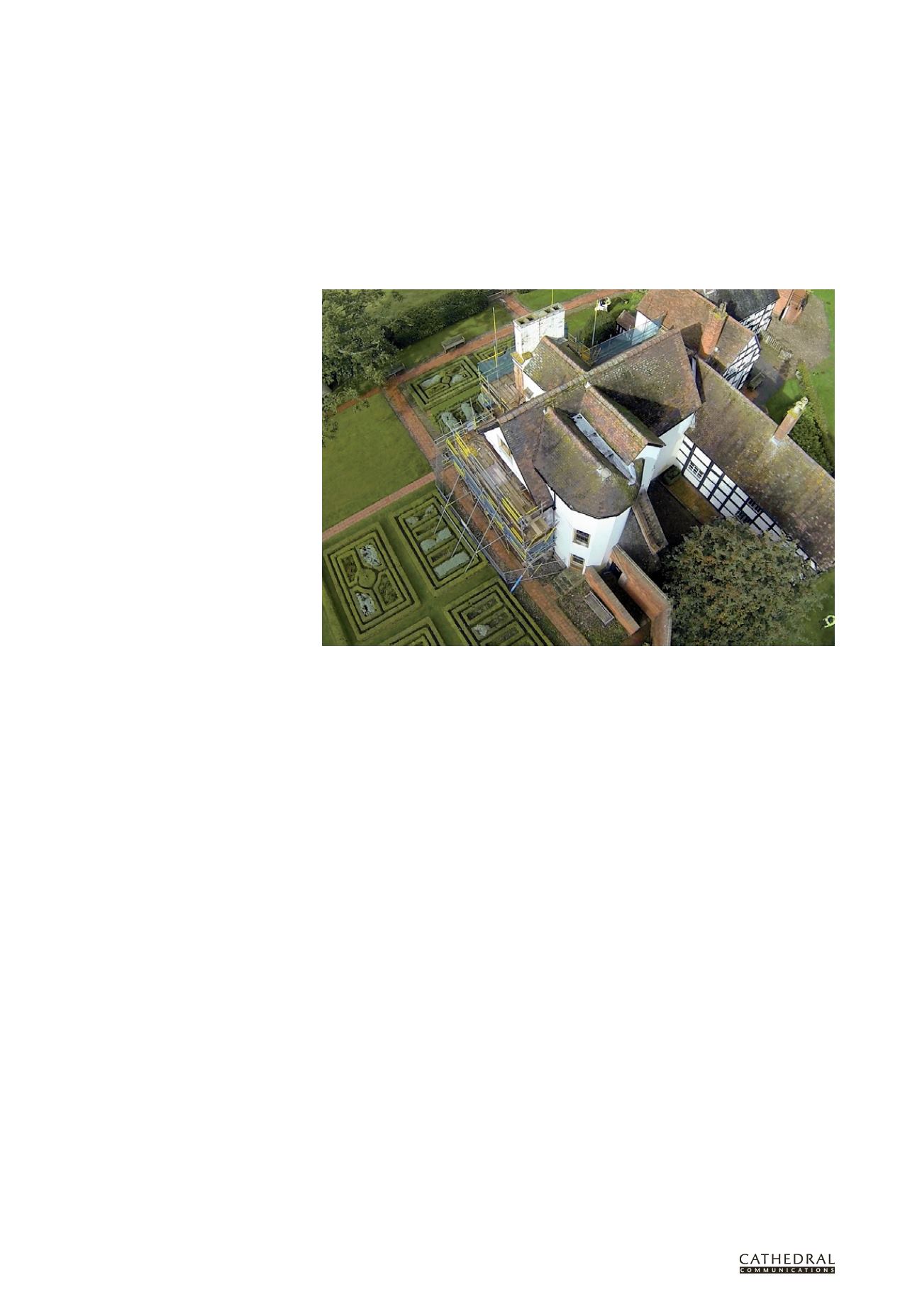
A drone’s eye view of the roof of Boscobel House, Shropshire