


 45 / 208

T W E N T Y S E C O N D E D I T I O N
T H E B U I L D I N G C O N S E R VAT I O N D I R E C T O R Y 2 0 1 5
4 3
1
PROFESS IONAL SERV I CES
although lightweight – typically 1–3kg
– they could do a great deal of damage
to a stained glass window. What might
seem to be easy to control and relatively
slow moving when flying in open air,
suddenly seems very much faster and
friskier when close to solid objects.
REGULATIONS
In the United Kingdom, the Civil Aviation
Authority is the regulatory authority for
all matters associated with non-military
aviation, including the operation of UAS.
Practice and regulation of small unmanned
aircraft has evolved out of the hobbyists’
use of radio-controlled model aircraft,
and remains reasonably simple and
straightforward, but as commercial use of
UAS increases, regulations and restrictions
are likely to become more stringent.
Essentially, the operator is fully
responsible for the safe operation of any
flight. In many circumstances a permission
(not a licence) from the CAA is required, for
example, if you intend to fly the UAS on a
commercial basis, or fly a camera/surveillance
fitted aircraft within congested areas, or close
to people or properties (vehicles, vessels or
structures) that are not under your control.
The CAA permission must be renewed
every 12 months and requires payment of a
modest fee depending on the weight of the
UAS. However, the ‘pilot’ does not need any
formal qualification (the Basic National UAS
Certificate for example) if the UAS is under
20kg and is flown in direct line of sight, within
500 metres horizontally and at a height not
exceeding 400 feet.
CAA permission is not required for
‘practice’ or demonstration flights, or if the
aircraft will not be flown close to people
or properties, and there is no ‘valuable
consideration’ (i.e. payment) for the flight.
Whatever the circumstance, anyone
contemplating any form of UAS flying
should familiarise themselves with the CAA
requirements (which are clearly defined
on their website), demonstrate adequate
competence as required and ensure that
they have adequate public and professional
liability insurance in place, and that they and
their insurers do actually understand the
competencies required and risks involved.
APPLICATIONS
At present, for the price of a good pair of
binoculars, a very capable ready-to-fly UAS
can reliably carry out detailed visual surveys
of inaccessible areas of buildings and other
structures. In a matter of minutes, detailed
images of high level stonework, inaccessible
metalwork such as weather vanes, chimney
stacks and concealed roofs and valley gutters
can be obtained. As always, it is far better if
the operator of the technology also has great
experience of surveying historic buildings,
so knows what to look for and where, and is
capable of identifying and analysing current
and potential faults. With instant FPV images
beamed back to the ground, this allows the
pilot/surveyor to concentrate in particular
detail on specific problem areas.
UAS aircraft can also be flown inside
large buildings, but this requires much
greater skill than flying outdoors. Proximity
sensors are now being developed that will
greatly reduce the risk of collision or damage.
Payload is always limited, but the aircraft
can carry very bright LED lights in addition
to cameras, which allows the detailed
visual survey of high vaulted roofs in large
churches and cathedrals, for example.
Aerial digital images from a UAS can be
integrated with terrestrial images of widely
different resolutions using currently available
software which can then process them to
produce 3D models of complex buildings such
as castles and cathedrals. Currently accuracy
is limited (typically 5mm to 20cm, across a
large and complex building, depending on the
system used) but should improve over time.
With any new technology, there is
often a rush of enthusiasm for its adoption.
It is quite possible for anyone to go out
and buy a £500 UAS and claim to be able
to survey your building. However, it is
most important that the operator is just
as fully experienced in interpreting and
diagnosing faults in historic buildings,
as they need to be in operating a UAS.
PREDICTIONS
As in the early stages of any new technology,
be it computers, mobile phones or indeed
manned aircraft, capabilities massively
and rapidly improve and real costs drop.
Predictions made in these early stages can
appear very wide of the mark only a short
time later, but UAS will almost certainly
become an accepted and common tool in
a specialist surveyor’s toolbox. Already, a
simple and palm-sized UAS aircraft, but still
with on-board camera, video recording and
a 100m range, can be bought for under £100
(thumb-sized and smaller are also available).
At the moment, a UAS can only inspect and
record, and further miniaturisation may not
offer much advantage, but greater control
and payload capacity might, for example,
allow accurate application of weed-killers to
inaccessible places.
What makes UAS technology particularly
interesting and difficult to predict is that
its emergence coincides with the arrival of
practical and relatively cheap 3D printers.
These two emergent technologies neatly fit
in with and greatly strengthen the worldwide
growth of the ‘Maker Movement’, with many
thousands of individuals around the world
openly sharing knowledge and skills. The
further development of UAS for civilian and
specific uses does not depend on military
funding or even big business.
At the current state of development,
compact and modestly priced UAS can reliably
provide detailed information that would
otherwise require the use of expensive and
time-consuming scaffolding, hydraulic access
platforms or specialist rope-access. A tall,
dangerous or inaccessible structure can be
surveyed very economically in a few minutes,
that might otherwise have taken many days
and cost thousands of pounds. It therefore
becomes economically viable to check
potential trouble spots such as inaccessible
valley and parapet gutters on a regular basis.
At the very least, a UAS survey should be
considered an essential element of every
quinquennial survey.
ROBERT DEMAUS
specialises in the non-
destructive assessment of buildings and
the detection and assessment of decay,
weakness and fire damage in structural
timber. He is a director of Demaus Building
Diagnostics Ltd
(see page 31)
.
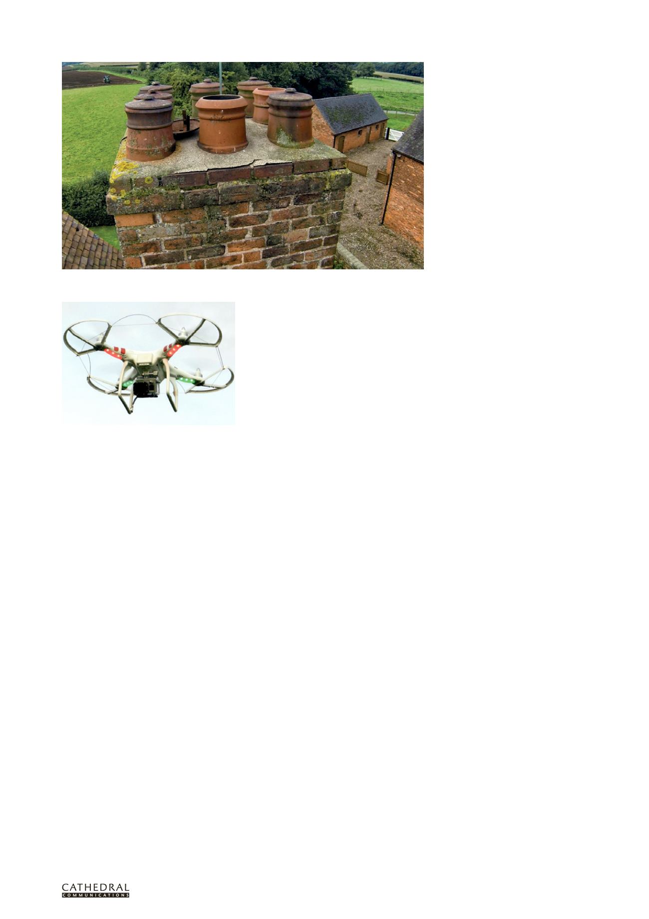
A typical compact (approximately 500mm wide)
four-rotor UAS carrying a GoPro video camera, as
used for the aerial survey of Boscobel House.
One of the chimneys at Boscobel: photos taken by UAS can quickly provide important information for a
quinquennial inspection and for programming maintenance